


画像1枚から遭難したハイカーの居場所を特定した人物がその特定法を解説

2021年4月13日、アマチュア無線家であり「画像の特定」が趣味であるベンジャミン・クオ氏が、遭難したハイカーが撮影した1枚の画像からおおよその居場所を特定し、連絡を受けた捜索隊が無事救助するという出来事が起こりました。見事な活躍ぶりを見せたクオ氏が、今回「どのように居場所を割り出したのか」を解説しています。
Since people are asking, how to geolocate a #hiker given only a general location and a grainy photo of their legs hanging off a cliff (thread) 1/x pic.twitter.com/81V0LGQdUk
— AI6YR (@ai6yrham) April 14, 2021
2021年4月12日、ルネ・コンペアン氏というハイカーが山で遭難し、1枚の画像を友人に送信した後に音信不通となってしまいました。友人が当局に通報し、当局が一晩の捜索の後に画像をSNSで公開したところ、クオ氏がこれに目を付けて画像の分析を開始。クオ氏は短時間でおおよその座標を割り出し、座標から約1.2km離れた地点で捜索隊がコンペアン氏を発見して、無事救助しました。
遭難したハイカーが「写真の特定が趣味の人」により速攻で発見される - GIGAZINE

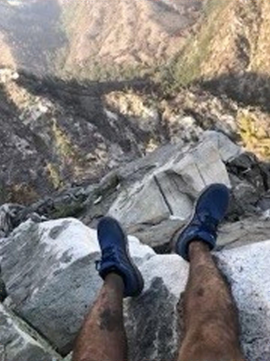
コンペアン氏が友人に送信した画像は以下。この日、コンペアン氏はカリフォルニア州のエンジェルス国有林に位置するウォーターマン山をハイキング中でした。
クオ氏は、まず「コンペアン氏がどのエリアでハイキングを行っていたのか」の特定にかかりました。コンペアン氏がウォーターマン山で遭難したことは当局のツイートから既に分かっていたので、ウォーターマン山を横切るエンジェルス・クレスト・ハイウェイの「北」か「南」、どちらでコンペアン氏が遭難したのかを絞っていきました。
2. If someone is lost along the Angeles Crest (if you keep tabs on the posts of @SEBLASD they post regularly on rescues), you find they are either NORTH of the Angeles Crest Highway or SOUTH of the Angeles Crest Freeway. How do we figure out which one here? 3/x pic.twitter.com/OdQWAHJzdk
— AI6YR (@ai6yrham) April 14, 2021
ここで衛星の画像が役に立ちます。クオ氏は衛星から撮影された地上の画像を数日ごとに更新し公開しているサイト「Sentinel Hub」を使い、コンペアン氏が撮影した画像と対照させていったとのこと。クオ氏は「Google Earthなどのアーカイブされた画像ではなく、今の山がどのように見えるのかを確認することは非常に重要です」と語ります。実際、エンジェルス国有林では2020年9月から3カ月にわたる大規模な山火事が発生しており、植生や風景が大きく変化していたとのこと。ハイキングに慣れていたというコンペアン氏も、救助後に「風景の違いから道を見失ってしまった」と語っています。
Here's where recent satellite data is important. The EU has the Sentinel-2 satellite (via @sentinel_hub EO Browser) which shows high resolution views of almost every place on earth, captured every few days. VERY important to see what something looks like NOW, not archived. 5/x pic.twitter.com/z64HRN3OET
— AI6YR (@ai6yrham) April 14, 2021
そして、クオ氏はエンジェルス・クレスト・ハイウェイの北には植物が少なく、南には植物が多いということを確認。コンペアン氏の画像にも緑が多く写っているため、クオ氏は「コンペアン氏はエンジェルス・クレスト・ハイウェイの南で遭難した」と判断します。
Google Earth has archived data, so it's tough to use the photo of the legs for any idea of where the photo was taken. Sentinel-2, on the other hand, shows where the vegetation roughly matches the background of the legs (green in the bottom but burnt/dry above). 6/x pic.twitter.com/9F2sSAzRvK
— AI6YR (@ai6yrham) April 14, 2021
そして、Sentinel Hubでいくつかの地点を調べたクオ氏は、コンペアン氏の画像に似ている風景を探し出しました。衛星画像は人の目線から撮影された画像と角度が違い、通常それ以上の特定は困難ですが、幸いSentinel Hubには3D視覚化ツールが導入されていたため、衛星画像の角度を変えて詳しい対照が可能だったとのこと。
Fortunately, @sentinel_hub recently added 3D visualization tools (you can also download the image to Google Earth as a JPG/KMZ if you wanted, but more steps). If you use those 3D tools and move around... you get this. 8/x pic.twitter.com/ogpIcmsQFj
— AI6YR (@ai6yrham) April 14, 2021
クオ氏が最終的に特定した画像は以下。崖の形が一致しており、クオ氏はほぼ間違いないと考えたものの、確証を得るために測定ツールや描画ツールを備えたGoogle Earthに移行します。
Hey, you say, I think I found what the lost hiker is looking at! Which leads to... 9/ pic.twitter.com/3tA43a9Vma
— AI6YR (@ai6yrham) April 14, 2021
そして、Google Earthの画像をコンペアン氏が遭難したと思われる時間に調整した結果、割り出した地点が間違いないと確信を得たとのこと。
Using the time/date feature of Google Earth (desktop).. bingo. Uncanny match (enough to convince SAR folks that no, I was not a stupid armchair detective with no clue ;-) 12/x pic.twitter.com/FFG8Vce7lD
— AI6YR (@ai6yrham) April 14, 2021
なお、クオ氏は「特定にかかった時間は21分でした」と語っています。
(Just for the record, the #geolocation I did the other day on the hiker thing took 21 minutes... asked a few times lately by reporters how many hours it took me -- have been saying 20-30 minutes-- and finally looked it up.). pic.twitter.com/1JkyCjE666
— AI6YR (@ai6yrham) April 20, 2021
・関連記事
地上1200m超の断崖絶壁でのキャンプ、死を背中に感じながらの寝泊まり - GIGAZINE
「金を出すほど死ににくい」、エベレスト登頂を支える経済学とは? - GIGAZINE
高さ900メートルのエル・キャピタンを世界最速で登る行程を約7分に収めたムービー「Two Nineteen Forty Four」 - GIGAZINE
ソ連の雪山で若者9人が不可解な死を遂げた「ディアトロフ峠事件」に科学的説明がついたという研究結果 - GIGAZINE
・関連コンテンツ
in メモ, Posted by log1p_kr
You can read the machine translated English article The person who identified the location o….