The AR navigation function of Google map finally starts testing for practical use, it is possible to accurately grasp the position information by just shooting with the camera
About the AR navigation function of Google Maps announced in May 2018, "Closed alpha test is done for release", The Wall Street Journal (WSJ) actually reported on participating in the test I will. This AR navigation function makes it possible to navigate with much higher precision than the conventional map application by using the camera of the smartphone.
It's the Real World-With Google Maps Layered on Top - WSJ
https://www.wsj.com/articles/its-the-real-worldwith-google-maps-layered-on-top-1154980720000
Augmented Reality Google Maps is coming, starts testing in private | Ars Technica
https://arstechnica.com/gadgets/2019/02/augmented-reality-google-maps-is-coming-starts-testing-in-private/
In Google's developer event " Google I / O 2018 " held in May of 2018, it was announced that navigation function corresponding to Augmented Reality (AR) will be installed in Google Maps.
Google map supports AR navigation function, allowing navigation by simply holding the camera - GIGAZINE
Although demonstrations were done with Google I / O so far, there are many examples that were not eventually released. Despite being announced that "ARM navigation function of Google Maps will be implemented within a few months", despite not having any notes from Google I / O 2018, it is whispered as "Does your store go into store?" It was. However, WSJ has lent a Google Pixel 3 with an alpha version of Google Maps, and reveals that he actually tried the AR navigation function of Google Maps.
by The Wall Street Journal
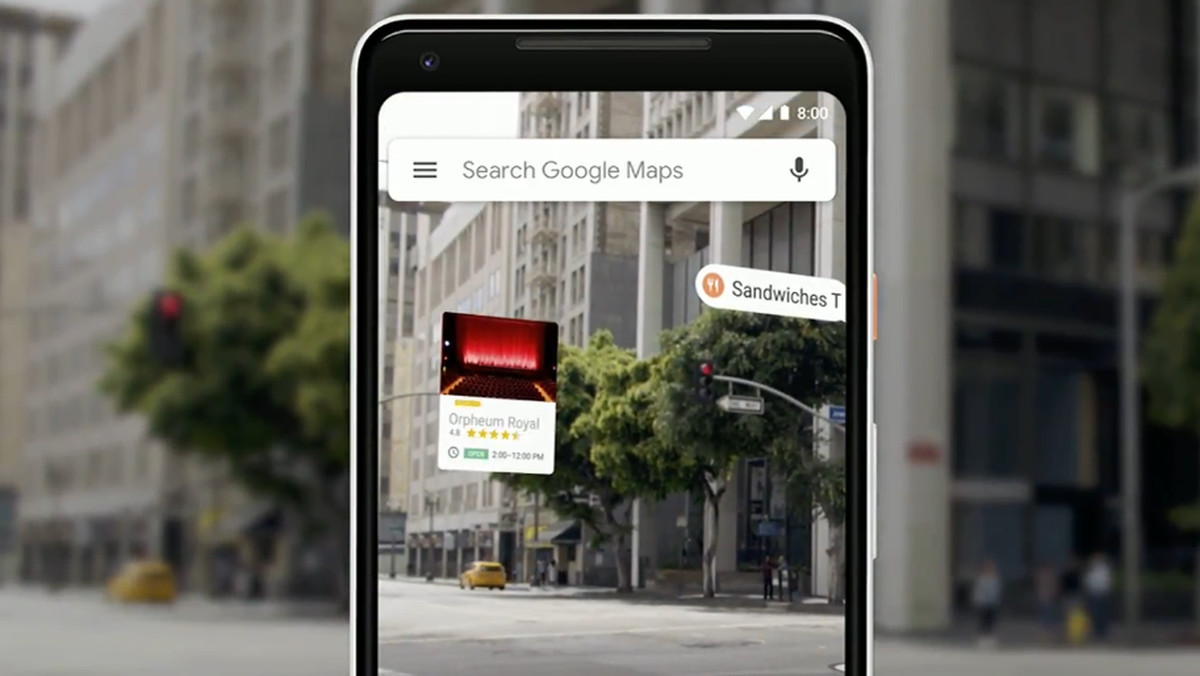
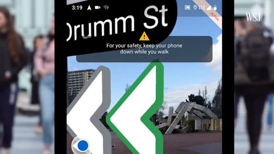
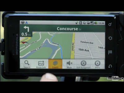
This AR navigation function is designed based on the image shot with the camera. According to WSJ, when you tap the "Start AR" button on Google Maps, the AR navigation function is activated and it seems that your current location was specified with amazing precision in a few seconds.
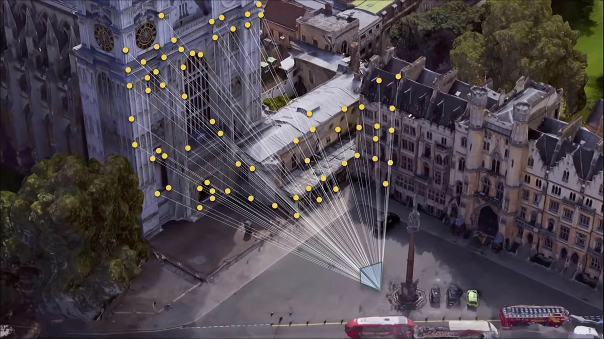
This AR navigation function is intended specifically for use in large cities. For example, in situations surrounded by indoor, underground, or skyscrapers, GPS does not work well and compasses on smartphones are often unresponsive. The "Visual Positioning System" (VPS, Vision Positioning System) adopted in this AR navigation function accurately captures the current location and direction by comparing enormous images of Street View with surrounding buildings photographed by the camera .
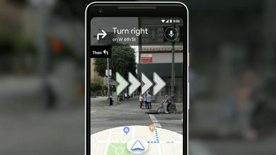
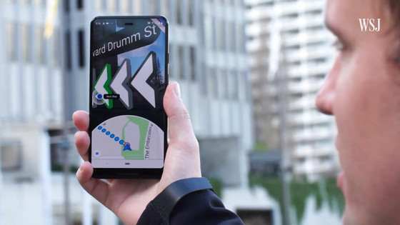
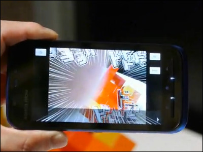
And, with Google 's ARCore tool kit, all the directions and shop information etc are all overlaid on the camera' s video in 3D. Of course, because walking smartphone is dangerous, it seems that the warning "Please lower your smartphone when you walk, for safety" appears to be displayed properly. In addition, the label "ALPHA" is displayed on the upper right of the screen as alpha version.
by The Wall Street Journal
Google has not concluded a specific release date, "The AR navigation function design of Google map is not completed and it is still being adjusted", but Google will finally release AR navigation function Fellows and ArsTechnica are staring.
Related Posts:


in Software, Web Service, Smartphone, Posted by log1i_yk