Why is the map drawn with "North" up?
ByJasperdo
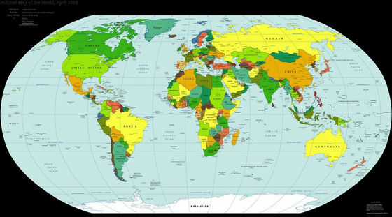
Along with the spread of smartphones and tablets, it seems that the place of activity of the map increased from a little going out to traveling. On such a map, in most cases, the upward direction is "NorthWhat is pointing to. I doubt thisAl Jazeera AmericaHowever, by following the old map, I am drawing out the answer of this mystery.
How the north ended up on top of the map | Al Jazeera America
http://america.aljazeera.com/opinions/2014/2/maps-cartographycolonialismnortheurocentricglobe.html
According to a study by Al Jazeera America, the answer to the question "Why does the upward direction of the map always show" North "?" According to the study of Al Jazeera America, in general "European people made maps and they wanted to be on top" . However, investigating areas around the world and old maps of various eras, you can see that there are other reasons for the top of the map facing "North".
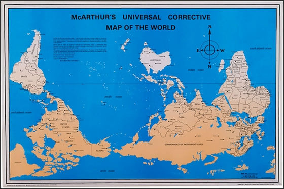
At present it is like deciding to make "North" on the map when creating a map. This is because the "McArthur's Universal Corrective Map of the World" announced by Australian Stuart MacArthur on January 26, 1979 is called an upside-down map clear.
By[email protected]
From those who use modern maps, it is very rare that something that the map's top direction is not "North". However, the fact that the top of the map is "North" is not necessarily geographically inevitable, rather, there are reasons for human beings and methods of making maps.
BySmithsonian American Art Museum
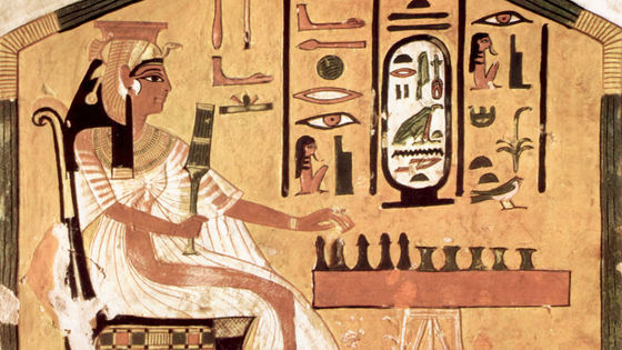
The map of ancient Egypt had "South" on the top. It seems to be because it expresses how the Nile River flows north in accordance with gravity. Also, in the Middle Ages most European maps brought "East" onto the map. At the same time, the Arab mapmaker seems to have brought "South" to the map. The reason for this is that each one placed the object of each faith (Jerusalem) and their country in a position that is easy to see on the map.
However, as time to investigate, these will change. In the 14th and 15th centuries an accurate map will appear to show the many port towns scattered around the Mediterranean Sea and its surroundings. It seems that there was no concept of up or down on the map as this map was made to allow the sailor to navigate the trade route by using it with the compass. However, on these maps, the compass and "north" were drawn so that we can see the direction.
ByDennis Wilkinson
Also, in schools where you learn Italian map creation law, there seems to be a time when it is fashionable to represent the "North" of the map's heading symbol with hats and arrows. Similar things have been done in Spain's Majorca, where the "North" of the map was represented by the North Star. The map producer from Mallorca made many customs such as "paint the Red Sea red on the map" and "draw the Alps like a big chicken foot".
ByJasperd
Although it is a compass that has an inseparable relationship with the map, it is said that China was the first to be used, and the word "Ginnan" used when teaching something always points to a certain direction "Finger nutI am coming from a car called "The car. When Europeans later began to use compass, the European sailors were already acquiring the technique of sailing using the "North Star" that shines in the northern sky. So, it seems that the compass was used to confirm "North" instead of Polaris in the night when cloudy stars can not be seen.
ByBrenda Clarke
Although it is compass originally used as a substitute for the Polaris, demand increases with the flow of the times and becomes essential for navigation in the 15th century. And gradually it began to bring "North" indicated by the compass needle on the map, except for some maps of Europe and Arab.
ByDan Iggers
According to Al Jazeera America, it was around the 16th century that "the map is northward" as an established fact. This is deeply involved with Ptolemy who is a Greek cartoon producer who was active in the 2nd century and who invented the approach of adding longitude and latitude to map production.
Geographies such as Geraldus Mercator, Henricus Martellus Germanus and Martin Wald Seemmler who played an active part in the 16th century seem to have duplicated and published the geography written by Ptolemy on a printing press. And he printed his portrait in a corner on the map created by Ptolemy attached to this geography book and added places and facts which were not known in the space of Ptolemy during the era of Ptolemy.
This geographical book and map spread to many geographers and mapmakers, but since the point on the map drawn by Ptolemy was pointing to "north", if Kore became a custom that continues to the present, And Al Jazeera America guesses. However, the reason why Ptolemy created the map so that the top of the map points to "north" was not known, and when I was sitting in Alexandria, "I myself understood sitting on the north side of the celestial body "It may be because I wanted to place Alexandria where Ptolemy was at the bottom of the map.
Related Posts:

in Note, Posted by logu_ii