The Ministry of Land, Infrastructure, Transport and Tourism is releasing a map that will give you a good idea of where 37 freeways will be freely available
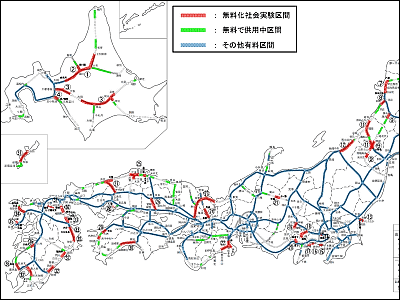
From February 2, 2010 the Ministry of Land, Infrastructure and Transport "FY2010 Freeway Free Social Experiment Plan (draft)"Was announced. This is the highway excluding the capital high speed and Hanshin Expressway, and the frequency of congestion occurrence due to the upper limit of 1000 yen on the holiday, the impact on other transportation facilities, the situation of the expressway network (paid / free continuity Etc.) and the budget that is taken into consideration. More concretely, it covers sections other than those connecting the three metropolitan areas · Sapporo, Sendai, Hiroshima, Fukuoka urban areas · routes mutually connecting these with the prefectural office locations, the capital city Approximately 18% and 1626 kilometers of the ratio of highway and highway excluding Hankoku to total extended extension are covered.
Although the start date is still unknown, this free trial experiment was conducted from about June 2010 to the end of March 2011, measures changes in traffic volume, traffic jams, etc. on expressways and general roads, and effects on regional economies, others It is said that surveys and analyzes will also be conducted on the impact of transportation on transportation.
So, in fact, let's see a map of where free is going to be free. Details are as below.
Press Release Presentation: FY2010 Freeway Free Social Experiment Plan (draft) - Ministry of Land, Infrastructure and Transport
http://www.mlit.go.jp/report/press/road04_hh_000011.html
This is the target section map of the free trial experiment. In the section where the red part will be newly free of charge this time, it is green section already being used for free.
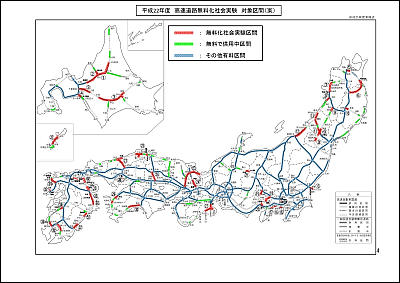
Each number on the above map is as follows.
◆ 1. Hokkaido: 319 km in total
No. 1: Road vehicle (Kenzen Iwamizawa by Dogen) 139 km
No. 2: Rumoi Sumo Expressway (Shenzhen West - Shenzhen JCT) 4 km
Number 3: Higashi Expressway (Honcho · Ashoro ~ Shinkansen, Yubari ~ Chitose Eniwa JCT) 130 km + 42 km
Number 4: Hidaka Expressway (Marsunoda West - Tomakomai Middle East) 4 km
◆ 2. Tohoku: 327 km in total
No. 5: Aomori Expressway (Aomori Higashi - Aomori JCT) 16 km
Number 6: Hachinohe Expressway 【Including Momochi Road】 (Momoko Shimoda · Hachinohe-Annai JCT) 87 km
No. 7: Akita Expressway 【Including Koto-ku Noshiro Road and Akita's External Ring Road】 (Hakuzu-Akita Central) 52 km
Number 8: Nihonkai Tohoku Expressway (Kawabe JCT ~ Iwaki) 17 km
No. 9: Tohoku Central Expressway 【Including Yuzawa Yokote Road and Yonezawa Nanyang Road】 (Yokote - Yuzawa, Higashi - Yamagata Kamiyama, Nanyo Takahata - Yonezawa North) 14 km + 27 km + 9 km
Number 10: Kamaishi Expressway (Towa ~ Hanamaki JCT) 11 km
Number 11: Yamagata Expressway (Sakata Minato ~ Yudonoyama, Tsukiyama ~ Yamagata Kita) 53km + 42km
◆ 3. Hokuriku: total 47 km
Number 12: Nihonkai Tohoku Expressway (Arakawa Teraiuchi - Niigata Central JCT) 47 km
◆ 4. Kanto: Total 108 km
Number 13: Higashi Mito Road (Hitachinaka - Mito South) 10 km
Number 14: Hachioji Bypass (Hammer-Aihara) 5 km
15th: Shon Shonan Bypass (Fujisawa ~ Chigasaki Coast) 9km
16th: Nishijyo bypass (Nishi Shoto Ninomiya - Hakone mouth · stone bridge) 15km
No. 17: Hakone Shinto (Yamazaki - Hakone Pass) 14 km
Number 18: Central Expressway [Including Higashi Fuji Goko Road] (Otsuki JCT ~ Sukuma) 41 km
No. 19: Chubu Crossing Expressway (Futaba JCT ~ Mariko) 16 km
◆ 5. Chubu: Total 90 km(It is written as 90 km instead of 91 km according to the material ※)
No. 20: West Fuji Road (Nishi Fuji - Fuji) 7 km
Number 21: Awa Pass road (Nakanosu to Hirayu) 6 km
Number 22: Ise Expressway · Koshi Motors (Mizu ~ Ise · Kiyoshi Ouchiyama) 78 km
◆ 6. Kinki: A total of 143 km
Number 23: Maizuru Wakasa Expressway (Obama West - Yoshikawa JCT) 112 km
24th: Kyoto Tamba Road (Tamba ~ Kakegawa) 31km
◆ 7. China: Total 195 km
No. 25: Matsue Expressway / San'in Expressway [Including Yasugi Road] (Yonago West - Higashiakumi, Matsue Tamazumi - Izumo · Mitsunoya Kisugi) 19 km + 45 km
Number 26: Okayama Expressway (Kita-JCT ~ Okayama JCT) 44 km
No. 27: Hamada Expressway / San-in Expressway 【Including Gangjin Road】 (Gotsu / Hamada ~ Chiyoda JCT) 71 km
Number 28: Hiroshima Kure Road (Nisho - kure) 16 km
◆ 8. Shikoku: total 92 km
No. 29: Matsuyama Expressway (Matsuyama - Osu, Osu Kitahara - Nishi Pref.) 42 km + 16 km
No. 30: Kochi Expressway (Kochi to Suzaki-e) 34 km
◆ 9. Kyushu: Total 249 km
Number 31: Yagiyama bypass (Honba Higashi - Sasugi) 13 km
32 kilometers: East Kyushu Expressway (Tsukiji - Shiida, Usa - Hinode, Oita Ronso - Saeki, Nobeoka Minami - Kagawa, Saito - Kiyotake JCT, Sueyoshi Department - Kajiki) 10 km + 31 km + 40 km + 4 km + 27 km + 33 km
Number 33: Oita Expressway (Hinode JCT ~ Hayami, Oita ~ Oita Ryora) 3km + 8km
34th: West Kyushu Expressway 【Takeo Sasebo Road and Sasebo Road】 (Takeo JCT ~ Sasebo Chuo) 30km
No. 35: Nagasaki bypass (Koga city cloth ~ Kawahira) 15 km
36th: South Kyushu Westbound Expressway 【Yatsushiro Nunoh Road and Kagoshima Highway】 (Yatsushiro JCT ~ Hinagu, Ichibe ~ Kagoshima Nishi) 12km + 21km
◆ 10. Okinawa: Total 57 km
Number 37: Okinawa Expressway (Oda-Naha) 57 km
In addition, as a reference material, the traffic congestion record with the holiday upper limit of 1000 yen (4th to 9th holiday, GW in the busy season, 5/2 to 5/6, Bon Festival: 8/13 to 8/16, SW: 9/19 ~ 9/23 excluding) will be the map below.

What kind of achievement will actually come out is a necessity.
Related Posts:
in Note, Posted by darkhorse
