Honda launches free provision of data showing road traffic jam information on Google Earth
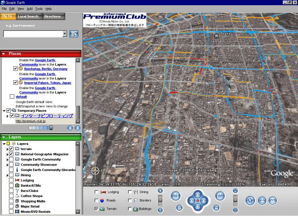
It is quite interesting system, it does not seem to be a real time update, but because it is updated three times a day, it seems to be convenient to use for confirmation before departure.
Internavi Premium Club Internavi floating car data on Google Earth TM
http://premium-club.jp/PR/lab/lab1.html
All that covers is Tokyo, Nagoya, Osaka.
The traffic information displayed is only floating car data collected by the Internavi floating car system, and VICS information is not included.
So, what is VICS or "floating car data" ...?
What is VICS 【Vehicle Information and Communication System】
http://e-words.jp/w/VICS.html
Transmit road traffic information such as traffic jams and traffic restrictions edited and processed at the VICS center in real time and overwrite it on the map prepared in the car navigation system and display it.
In addition to providing information on traffic jams, construction, etc., it also has the function of displaying the congestion status of parking lots, etc. for most highways and general roads in urban areas.
That is, it seems to be the thing that displays traffic congestion information on a car navigation system.
Report material: What is VICS (road traffic information communication system)
http://www.ttb.go.jp/hodo/h1410-12/1118b6503.html
[Provide information]
● Traffic information
There are traffic jam information, traffic jam location, degree of traffic jam etc.
The top position of congestion and length of congestion are expressed up to 100 km.
"Congestion", "Congestion", "No traffic jam", "Unknown" in four categories.
● Event rule information
Up display of classification into 14 kinds such as "road closure" and "speed regulation".
● Travel time information
Display time required between intersections and between town and town.
● Parking information
Information on each parking lot is indicated by "empty car", "crowded", "full car", "closed", "unknown".
It seems quite useful, but what is this relationship with Honda ...?
Internavi Premium Club Inter Navi VICS - floating car system
http://premium-club.jp/PR/technology/tech1.html
The route on which VICS information is expected to be provided is about 330,000 km nationwide, but it is said that the sensor is installed and the section where data necessary for route guidance is provided is said to be about 42,000 km.
(As of the end of March 2006 · Honda investigation)
The Internavi Floating Car System (Premium Membership VICS) collects traveling time data of roads not provided with VICS information by using the cars themselves of the Internavi Premium Club members as a sensor, and mutually provides and utilizes between them It is a system.
In other words, do you make it possible to realize things like VICS even in places without VICS terminals?
It seems that the data displayed by Google Earth this time is this floating car data.
So, how reliable is the data of this floating car system?
Honda's Internavi floating car data achieved cumulative mileage of 100 million kilometers
http://www.honda.co.jp/news/2006/c060329.html
The accumulated mileage collected by Honda's "Internavi Premium Club", the service provided by the Internavi Floating Car System, reached 100 million kilograms equivalent to about 2,500 laps of the earth in the middle of March.
It was achieved in about two and a half years since we first commercialized the floating car system in the world as an automobile manufacturer in September 2003.
Also, we release traffic information collected by Internavi Floating Car System for the first time in Japan using "Google Earth ™" and will release it from March 29th today.
That seems there are currently 350,000 members. It may not be safe to judge that reliability is "there" rather.
Related Posts:


in Web Service, Posted by darkhorse_log