The reason why distance measurement using GPS can not escape error is proved by mathematical formula
ByDavid Fulmer
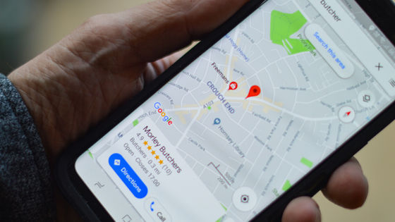
A satellite positioning system that receives a radio wave from an artificial satellite and specifies a position on the ground,GPSIf you are using it, you may find that sometimes errors occur. Also, when you actually measure the distance traveled by the jogging application or the movement log application, the distance may be displayed longer than it actually is, but the background may include mere "error" and algorithm problems There seems to be another reason different from that, and one research team has proven its occurrence by mathematical formula.
GPS Always Overestimates Distances
http://www.i-programmer.info/news/145-mapping-a-gis/9164-gps-always-over-estimates-distances.html
Why Every GPS Overestimates Distance Traveled - IEEE Spectrum
http://spectrum.ieee.org/tech-talk/at-work/test-and-measurement/why_every_gps_overestimates_distance_traveled
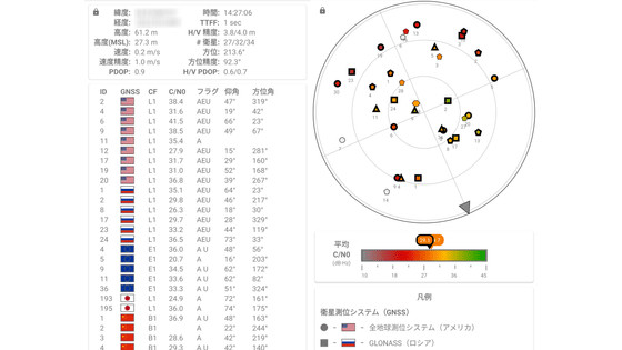
Many people know that GPS and other satellite positioning systems are systems that measure their own position by receiving radio waves emitted from multiple artificial satellites flying in space. The image looks like the following GIF animation, finds "satellite in sight (visible sat)" from among many artificial satellites flying through the orbit like the mesh eye, picks up the radio waves (green ), You can determine your own position three-dimensionally by performing complex calculations.

ByShushruth
In actual operation, for example, in the case of a smartphone, it obtains the information of the Wi - Fi signal in the vicinity of the GPS signal, etc, etc, to raise the accuracy of the positioning. Although it is a GPS system equipped with multiple correction mechanisms like this, there are still reasons why errors still remain.
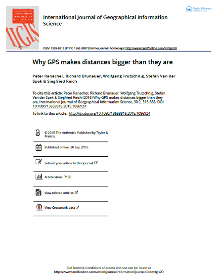
It is the research team of Salzburg Forschungsgesellchaft (Salzburg research firm), the research institution of Salzburg University in Austria, and Delft University of Technology in the Netherlands, which clarified the reason. The research team unveiled that a numerical value larger than the actual distance is measured when the moving distance is measured by the GPS, and the error of the distance measurement has bias (deviation) caused by the system We are clarifying that.
(PDF)Why GPS makes distances bigger than they are - 13658816.2015.1086924
Route measurement by GPS can not escape the influence of interpolation error when filling the space between multiple measurement points and error at the time of measurement. Causes of this error include delay caused when radio waves propagate due to the influence of the atmosphere, error of position information occurring in the satellite floating in the sky itself, deviation of the atomic clock mounted on the satellite, The reflection of radio waves occurring in buildings and the like, and factors such as "the satellite position is too low with respect to the horizon", "each other's satellite is too close", "there are too few visible satellites" It is said that there is. The GPS device corrects for such errors and obstacles and then pulls out the current position.
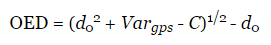
The research team found that the distance between two points measured from the position information obtained from the information having irregular errors is generally larger than the actual distance, based on the calculation formula It was proved to be. Actual distance between two points "D 0"And the variance (dispersion) as an index indicating the accuracy of measurement"Var gps", Autocorrelation"C"Overestimation of Distance:OED) From the following expression, if the autocorrelation "C" is smaller than the variance "Var gps" which always shows a positive value, the answer shows a positive numerical value (= a larger distance than the actual) I will. And, in most cases the autocorrelation "C" is a smaller value than the variance "Var gps".
This "problem" means that users using GPS will become prominent when measuring the total distance by stacking distances of multiple points. There is an error with the actual distance at the distance measured based on the GPS, but as mentioned above, since there is a bias that the number showing more numerical value than the actual number is large, the number of measurement points is large In other words, there is a high possibility that the error will increase.
In addition, the research team seems to confirm this logic even in the actual state. In the experiment, we draw a square of 10 meters square in a large parking lot and a reference point to measure the position every 1 meter in the straight line of 4 sides. And, it was said that participants in the experiment got the GPS terminal, and when they rounded over the four sides, they got 25 laps and measured the position at each reference point.
As a result, the distance between two points flicked out by GPS measurement is on average for measurements of 1 meter1.2 meters, When measured at 5 meters5.6 m, And it turned out that a numerical value which is 12% to 20% larger than the actual distance is shown as a whole. The research team is also conducting similar experiments using automobiles in wider areas, but here also the results of the same trend are being obtained. In the paper, the satellite positioning system used for the experiment is the AmericanGPSOr, in RussiaGLONASSIt is not touched whether it is a system, a system other than that, or a combination of these.
ByRiccardo Romano
In this way, it has been proved by mathematical equations and experiments that constant error occurs in the distance measurement using GPS, but on the other hand it does not necessarily conclude that "GPS measurement is not usable" And that. Even with the same GPS, the same error does not occur in the method of measuring based on velocity (speed), so we can also say that we can measure the distance accurately enough.
Related Posts: