Why doesn't Google Maps' location information become more accurate even if GPS becomes more accurate?

Smartphones and car navigation systems use GPS to pinpoint your current location with high accuracy. However, when you refer to your current location on Google Maps, it is often shown as a circle instead of a dot, and even if the GPS is highly accurate, the location information is still not displayed accurately. The science news site Nautilus explains why.
What Happens to Google Maps When Tectonic Plates Move? - Nautilus
https://nautil.us/what-happens-to-google-maps-when-tectonic-plates-move-237678/
According to Ken Hudnut of the United States Geological Survey, the discrepancy in Google Maps is not only due to GPS accuracy, but also due to georeferencing, which links the map's coordinate system to the geographic coordinate system.
For example, a 2008 study examining Google Earth imagery for 31 cities in developed countries found errors ranging from 1 to 50 meters, which could be due to drift in georeferencing over time, rather than just the accuracy of the GPS units.
'We're in an age where people want centimeter-level accuracy on their smartphones, but eventually maps and GPS accuracy will no longer match, and many people will be left scratching their heads,' said Drew Smith of the National Geodetic Survey (NGS).

Maps are made based on surveying. However, although the ground on which the surveying is carried out appears to be stationary, in reality it is constantly moving at an invisible level. According to the plate tectonics theory, which has been proposed since the late 1960s, the surface of the Earth is covered by bedrock called 'plates' that are several tens of kilometers thick, and it is believed that these bedrocks are constantly moving.
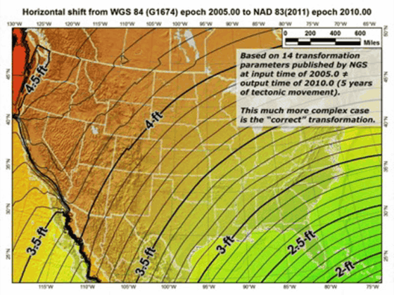
NGS has established a reference coordinate system called 'NAD83' for surveying the North American continent. This NAD83 is an important coordinate system for surveyors in North America because it is aligned with the movement of the North American plate. On the other hand, GPS uses 'WGS84', a reference coordinate system for the entire Earth.
It is known that there is an error of several meters between NAD83 and WGS84, and that the deviation is gradually increasing. NAD83 does not reflect knowledge of the shape and size of the Earth, and the coordinates of the center of the Earth are about 2 meters off from WGS84. NGS will update NAD83 in 2022, but it is said that the deviation of about 1 meter remains.

In the Great East Japan Earthquake that occurred in 2011, GPS captured plate movement in real time. It is known that the coastline near the epicenter moved horizontally by up to 4 meters. Below is a movie created by Ronnie Grapenshin, a geologist at the University of California, Berkeley, based on data from the Geospatial Information Authority of Japan, which summarizes in real time from the occurrence of the earthquake whether the displacement occurred in the east-west (horizontal) and north-south (vertical) directions at each point.
Sendai/Tohoku-oki earthquake displacements 1Hz data - YouTube
When such a large earthquake occurs, the surface of the earth can shift significantly along the fault, sometimes by several meters. It takes time for these changes to be reflected on maps, so the discrepancy between GPS positioning information and maps is getting wider and wider.
Related Posts:


