If you explain in an easy-to-understand manner how GPS measures location information, it looks like this

GPS, which measures the current location using satellites, is used in many places such as map apps and car navigation systems, and has become an indispensable system for modern human life. Mr. Bartosz Ciechanowski, who has created an easy-to-understand explanation page on the mechanism of the camera and the rotation and revolution of the earth, explained such a GPS position measurement mechanism, so I summarized it.
GPS – Bartosz Ciechanowski
https://ciechanow.ski/gps/
◆ How to measure the position on a plane
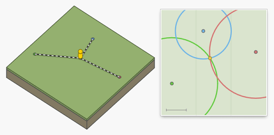
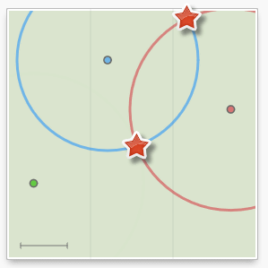
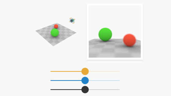
Ciechanowski first prepares a plane with the following three points of green, blue, and red instead of the earth, and explains how the yellow doll on the plane measures its position. ..

The information required to measure the position on the plane is 'the position of the green / blue / red dots' and 'the distance from the green / blue / red dots to the doll'. After measuring the 'distance between the point and the doll', draw three circles with the 'distance between the point and the doll' as the radius around each point, and the intersection of the circles will be the position of the doll. The method of finding the position based on such a distance is called three-range multilateration , which is the basis of position measurement in GPS.
Everyone knows that speed can be calculated by dividing the distance by time, and distance can be calculated by multiplying speed by time. By using this law, it is possible to calculate the distance using 'sound' that has a constant speed. For example, if you create a mechanism that 'each point emits light when the sound emitted by the doll arrives', the doll measures the time from 'the timing when it emits the sound' to 'the timing when each point emits light'. By doing so, the distance to each point can be derived.

By deriving the distance as described above, the position can be determined using the three-sided survey as long as the 'time until the sound emitted by oneself reaches the point' is known. Now you can figure out the position without measuring the distance with a ruler.

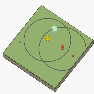
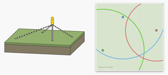
However, if there are two dolls as shown below, it will not be possible to determine which doll emits the point in response to the sound, and it will be difficult to determine the position. It may be unusual for two dolls to make sounds at the same time, but if there are billions of objects like a real GPS, it's easy to create a situation where multiple objects make sounds at the same time. , It will be difficult to measure the position.
A smart way to solve this problem is to use 'sounds from dots' instead of 'sounds made by you'. By doing this, even if billions of dolls ask for location information at the same time, they will be able to ask for location information without interfering with other dolls. However, when using 'sound emitted from a point', a new operation of 'matching your own clock with the point clock' is required.
When I was using 'the sound I made', I was able to measure both 'the timing when I made the sound' and 'the timing when each point emits light' with my own clock, so I need to set the clock. There was no. However, when using 'sound emitted from a point', it is necessary to measure 'timing when the point emits sound' with the clock of the point and 'timing when the sound reaches itself' with its own clock. For this reason, if the two clocks do not match exactly, the exact distance cannot be calculated and it becomes impossible to measure the position information.
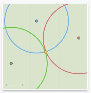
In fact, there is a smart solution to this clock-matching problem. When the clocks of the three points are perfectly synchronized and the sound is transmitted at the same time, if the clock of the doll is off, there is one three circle whose radius is the distance calculated based on the 'time when the sound was heard'. The three circles meet in one place only if the clocks match exactly. In other words, even if your clock is off, you can measure your position while adjusting the time by adjusting the clock so that the three circles intersect at one place after you hear all the sounds emitted by the three points. That's why.
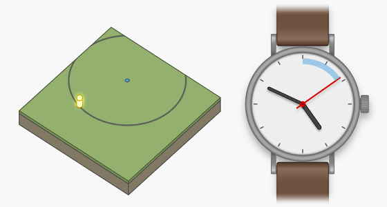
It seems that clock adjustment is not necessary if clock adjustment and positioning can be performed at the same time, but clock adjustment has the advantage of speeding up positioning. If the clock is right, you can narrow down the location information to two points when you hear two sounds as shown below. In terms of global size, one of these two points basically indicates a point far away from where you are, so you can determine the position when you hear the two sounds.
◆ How to measure the position in the 3D world
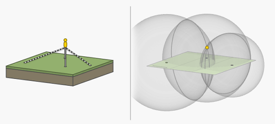
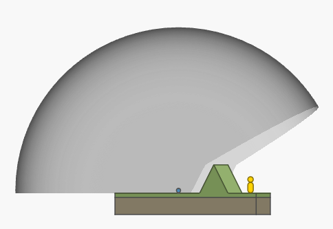
The above positioning method is for a plane and cannot be used as it is in the real world where there is a height difference. For example, if the doll is in a high position as shown below, even if you draw a circle based on the distance from the point, it will not intersect at one place.
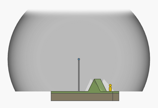
To measure the position in the world in such three dimensions, it is OK to use a 'sphere' instead of a 'circle'. If you draw a sphere whose radius is the distance from the point where you want to obtain location information, you can make two intersections of three spheres.
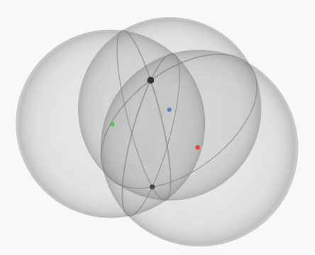
Using the above method on the real earth, one of the two points would indicate underground or deep sea. Therefore, the position can be measured in the same way as a plane by using a 'sphere'.
◆ How to measure the position on the earth
If the above positioning method is applied to the real earth, the use of 'sound' will make noise every time the position is measured, so the use of sound is not suitable. In addition to sound, there is 'light' that has a constant speed, but visible light is easily blocked by clouds, fog, dust, smoke, and so on. For this reason, actual GPS uses 'radio waves' that are not easily blocked by clouds and dust.
Also, if the source of radio waves is near the surface of the earth, it will not be possible to overcome terrain such as mountains and hills ...
If the source of the radio wave is placed at a high place as shown below, the radio wave can be delivered to the object without being affected by the terrain.
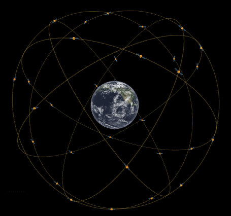
However, it is difficult to actually build a tower higher than Everest, the highest in the world. The idea to solve this problem is to send the source of radio waves into the satellite orbit. With GPS, about 30 artificial satellites realize the idea and enable highly accurate positioning all over the world.
In addition, as mentioned above, the positioning system is required to keep accurate time, but GPS satellites are equipped with an atomic clock that causes an error of only 1 second in 300,000 years, ensuring time accuracy. It has been.
In addition to the above contents, the explanation page by Mr. Ciechanowski also explains the details of the GPS orbit and the contents related to the transmission of radio waves. In addition, there is also a demo that you can understand while moving with the mouse, so if you are interested, it is recommended to actually access it.
GPS – Bartosz Ciechanowski
https://ciechanow.ski/gps/
Related Posts:


in Note, Posted by log1o_hf