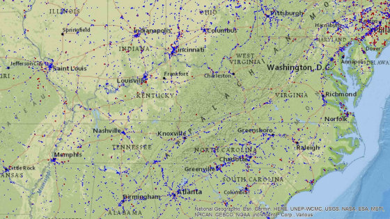
It turns out that the government has closed the map `` Toxmap '' that visualized the area polluted by toxic substances

` ` Toxmap, '' which visualizes air, water, land, etc., contaminated by toxic chemicals on a map, summarizes huge and complicated data so that even non-experts can easily understand it, and students and researchers Until now, it was used for various purposes. However, suddenly the closure of Toxmap was announced in mid-December, and it was actually closed without further explanation. Experts have expressed concern that the closure would hinder public access to environmentally hazardous data.
Federal Toxmap Shutters, Raising the Ire of Pollution Researchers
Toxmap was released in 2004 by the National Library of Medicine to visualize locations where hazardous chemicals (TRI) are being released. Toxmap information is based on reports from facilities located in the United States, and pollution information includes underwater, airborne and underground. It was also possible to identify the contaminated facilities on the map, track the year and period of the contamination, aggregated data during the period, and trends over time.
Below is a screenshot of Toxmap. Red and blue dots indicate contaminated areas, and red dots indicate 'the most polluted land in the country'.

By using Toxmap, users can obtain data on locations where harmful substances have been released and overlay them with death statistics and other maps, so that they can be used by students, activists, researchers, It was handy by the community.
On December 16, 2019, it was announced that this Toxmap was suddenly shut down without detailed explanation.
TOXNET Website to be Retired, Most Content Will Remain Available.NLM Technical Bulletin.2019 Sep–Oct
https://www.nlm.nih.gov/pubs/techbull/so19/so19_toxnet_discontinued.html
At the time of writing the article, Toxmap is inaccessible, and a website providing similar information is presented.
TOXNET HAS MOVED
https://www.nlm.nih.gov/toxnet/index.html

Claudia Persico, an environmental scientist at the American University and Chris Sellers, an environmental historian at the State University of New York at Stony Brook, commented, `` We have really shut down this tool, which is essential for the U.S. National Library of Medicine to properly understand the environment. I'm surprised that this has happened. '
Later, the National Library of Medicine in a statement to the news media Undark explained that the library had `` needed some difficult organizational changes '' to achieve the goals of the new strategic plan. , Said that partial Toxmap data was scattered on US and Canadian government websites. For example, the United States Environmental Protection Agency's Enforcement and Compliance History Online allows you to enter a zip code and see some data on nearby sources of pollution and toxic emissions.
However, researchers point out that 'these information is becoming very complex and so large that it is difficult for untrained people to use it.'
Data sharing tools such as Toxmap originated from the Bhopal chemical plant accident in the 1980s. In this accident, toxic gas hit stricken areas, killing 2,000 to 10,000 people. Following the Bhopal accident, U.S. lawmakers called on the 'right to know' to share the dangers of potential toxics in the community. In 1986, the law `` EMERGENCY PLANNING AND COMMUNITY RIGHT-TO-KNOW '' required companies to report the use of toxic substances to the Environmental Protection Agency, and the information gathered here was made visible to the public. It was Toxmap.
Toxmap was launched by the U.S. National Library of Medicine, which is part of the National Institutes of Health, but those who actually worked on the service said that the tool was 'made easy to understand and use.' Talking. As a result, Toxmap has been used in a wide range of situations, from student projects to research papers. Sara Wylie, a researcher at Northeastern University who actually uses Toxmap in the project, said Toxmap is a tool that clearly shows students `` How widespread toxic substances are spread in the United States ''. Is. 'Toxmaps showing the toxic emissions and their complexity near students were always shocking for students, a very unique resource,' said Wylie. He emphasized that he used Toxmap in his scientific papers and talked about how Toxmap was a valuable tool.
Related Posts:
in Web Service, Science, Posted by darkhorse_log


