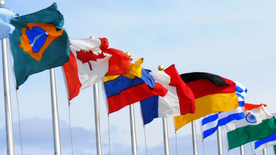
What is the route of "latitude" and "meridian" passing through the most countries and regions?
On the surface of the earth is a line connecting the Antarctica and the Arctic "meridian"Drawn parallel to the equator"Latitude lineTwo virtual lines are drawn so that you can indicate the location of every place. In other words, meridians and latitude lines traverse or cross the countries and regions all over the world, but indeed the person who has ascertained the mystery "where are the meridians and parallels passing through the most countries and regions?" There is.
Which lines of longitude and latitude pass through the most countries? - From the Heart of Europe
https://nwhyte.livejournal.com/2929721.html
In order to clarify this mystery, Nicholas · White who is from Ireland and has a title such as political scientist, SF fan, medieval researcher. Mr. White, who received a question from a friend, investigated which meridian and latitude pass through the most countries, mainly using Google Maps and its extension tools.

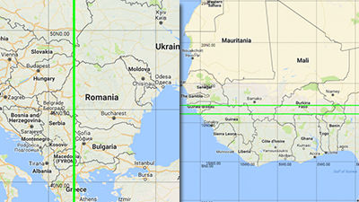
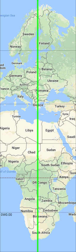
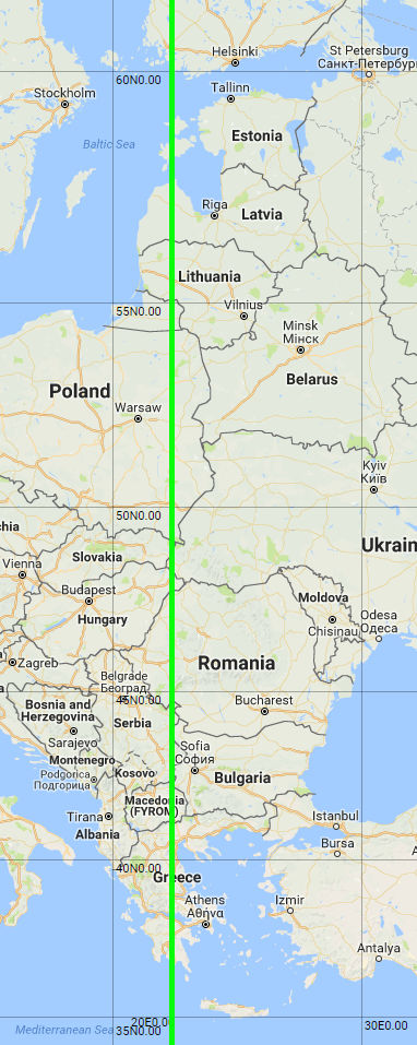
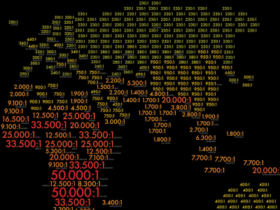
The meridian passing through the most countries was a line extending 22 degrees 31 minutes 35.2 seconds east longitude 22 degrees 33 minutes 32.1 seconds east. It is a line with a width of about 2 minutes by longitude, but since it actually fits in the width of about 20 km near the equator, it seems to be said to be a level that can be cleared up as an error when considered on a global scale. The country through which this line passes 1 from the north. Norway, 2. Finland, 3. Sweden, 4. Estonia (Western Estonian Islands), 5. Latvia, 6. Lithuania, 7. Russia (Kaliningrad State · Enclave), 8. Poland, 9. Slovakia (slightly easter), 10. Ukraine (a little western part), 11. Hungary (slightly eastern part), 12. Romania, 13. Serbia (slightly easter), 14. Bulgaria (little western part), 15. Macedonia (slightly eastern part), 16. Greece, and the Mediterranean Sea, 17. Libya, 18. Chad, 19. Sudan (west only), 20. Central African Republic, 21. Democratic Republic of the Congo, 22. Angola, 23. Zambia (western part only), 24. Namibia (part protruding to the east), 25. Botswana, 26. It is 26 countries in South Africa.
Expanding around Europe, it is passing through the densely populated region of Eastern Europe from the West Estonian islands of Estonia floating in the Baltic Sea, passing through the Peloponnesos peninsula protruding most south in the part in contact with the continent of Greece and passing through to the Mediterranean Sea I understand.
Likewise, you can see that even on the African continent, it passes through the most borderline entry area. In Sudan a small area of the corrupted border is hazy, and in Namibia in the south of AngolaCapri ValleyIt penetrates the territory protruding east called.

Although it was said that the meridian was relatively easy to determine, one latitude line seems to have been bothered by a slight headache. As a result of examining various latitudes, I found a country which should be counted as "28th" in both lines, but both of them found that there was no factor which was both determinant and determinant. As a result of the examination, Mr. White is 11 degrees 08 minutes 02.4 seconds north latitude and 11 degrees 08 minutes 25.8 seconds north latitude "Togo - Tobago Line", From north latitude 12 degrees 11 minutes 03.7 seconds to north latitude 12 degrees 11 minutes 34.4 seconds"VicarainI have chosen two of them.

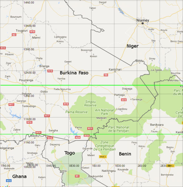
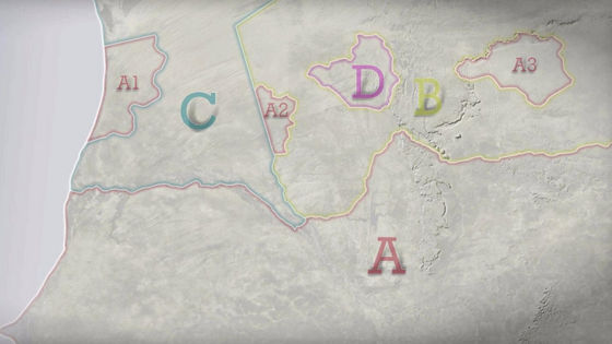
On the north side of the following map is Vicarain, its north-south width is less than 1 km. And the Togo - Tobago line in the south has a north - south width of about 700 meters, both of which have a very narrow range. When counting from the west end of the continent of Africa, both lines entered from Guinea Bissau (1/1) then go through Guinea (2/2) and enter Mari (3/3) and Burkina Faso (4/4). (The numbers behind the country name are Vicarain and Country Count of Togo-Tobago Line in turn)
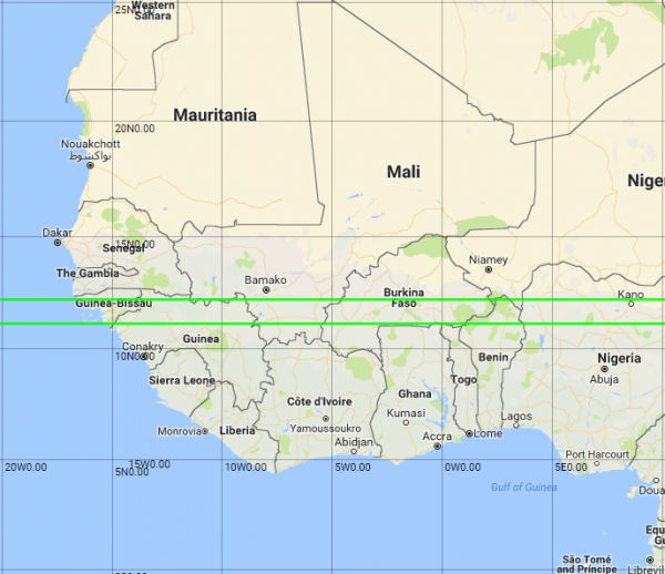
In the next fifth country, differences will begin to appear in both lines. The Vicarain passing through the north passes from Niger (5 / *) to Benin (6/7), but the Togo - Tobago line in the south is Ghana (* / 5) and Togo (* / 6) Grazing a small part again enters Burkina Faso and leads to Benin (6/7).
Later on, both lines are in Nigeria (7/8), Cameroon (8/9), Chad (9/10), Sudan (10/11), South Sudan (11/12), Ethiopia (12/13), Djibouti (13/14).
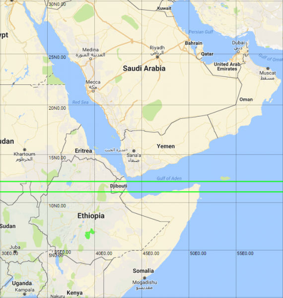
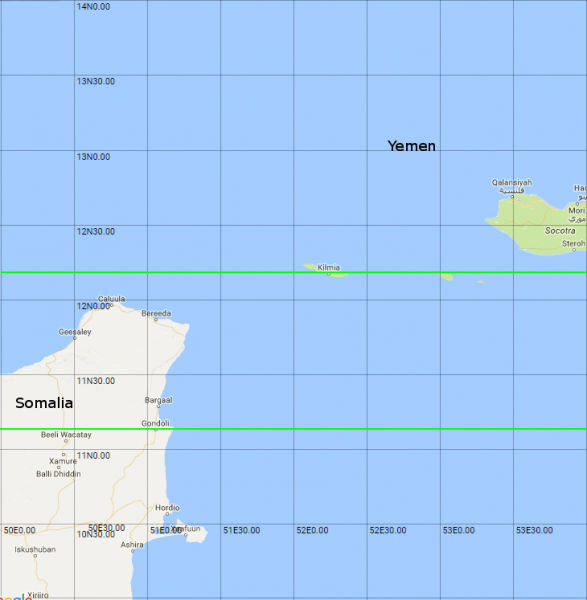
After Djibouti, the Togo - Tobago line passes through the northern part of Somalia (* / 15) and enters the Arabian Sea. Meanwhile, although Vicarain slightly misses Somalia, he counts Yemen (14 / *) and enters the Arabian Sea as well.
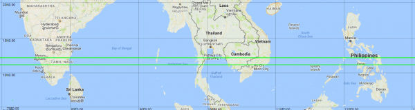
After that, both lines passed through India (15/16), Myanmar (16/17), Thailand (17/18), Cambodia (18/19), Vietnam (19/20), Philippines (20/21) Go to the Philippine Sea, the Pacific Ocean.
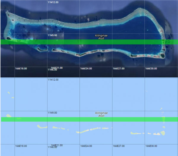
Next, both lines will encounter Marshall Islands (21/22). In this Marshall Islands, both lines go through the land with a barefoot line.
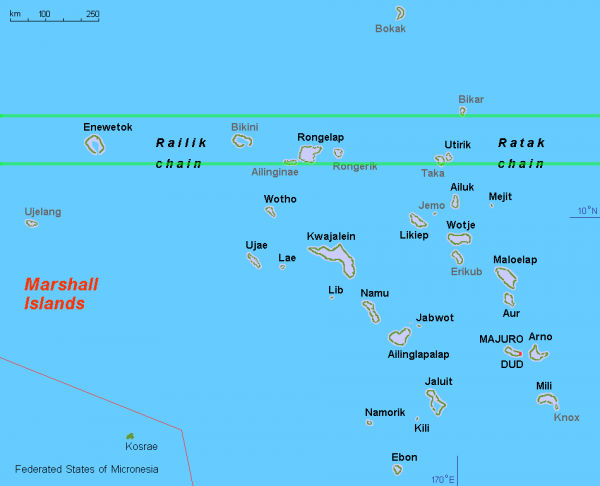
The Togo - Tobago line passes over a slight land of the Eringing Atoll.
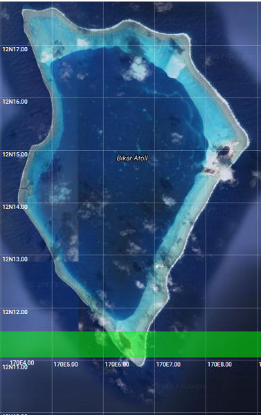
One Vicarain is a route that goes through Viker Island which became its name. Vicarain extends in the east and west direction to swallow a small Vicar Island located at the southern end of a large atoll.
After the Marshall Islands, the area without land continues for approximately 11,000 km. Later, both lines landed in Nicaragua (22/23). After only the Togo - Tobago line increases the number through Costa Rica (* / 24), both lines go through Colombia (23/25) and Venezuela (24/26).
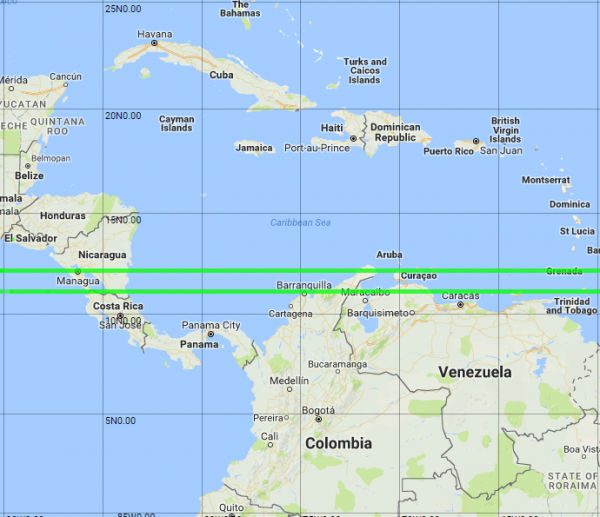
In addition,Curacao(twenty five/*),Bonaire, Sinto Eustatius and MackerelWe go through Bonaire Island (26 / *) and finish the last country at Grenada (27 / *) located in the end.
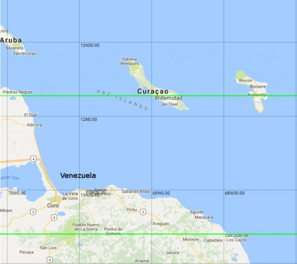
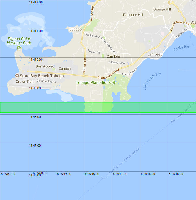
One Togo-Tobago line will be the last countryTrinidad and Tobago Republic(* / 27) passed through the island of Tobago and finished.
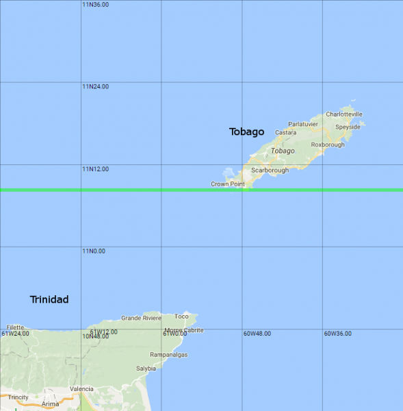
The line that passes through Tobago is barely scratching this girigiri area barely. This resulted in the same number and two draws on the two lines.
In the end, Mr. White writes annotations about each line and points out the problems that each line has. According to the contents, Mr. White seems to decide which line to win.
· Vicarain
Curacao and Bonaire are Dutch territories, respectively, and subtleness remains to count as an independent nation. If we were to count them all together with "Netherlands", the result of the Vikar line was "26 countries".
· Togo ~ Tobago line
Taking into account the historical background, in the area counted as "Somalia" this timeSomalilandWhenPuntlandIt is thought that there are two countries of Mr. White and that view is supported. , The count number of Togo - Tobago line is "28 countries"It can be regarded as the number of countries larger than the Vicarine line.
Related Posts:

in Note, Posted by darkhorse_log