Google map has evolved colorfully and in detail, 5 images that you can compare the differences with a slider

Google Maps, which celebrated its 15th anniversary from the start of the service , extracted the features of the local nature using satellite images, and in the color range of the HSV color model , 'forest is dark green' 'shrubs are light green' Updated to look colorful.
A more detailed, colorful map
https://blog.google/products/maps/more-detailed-colorful-map/
Google publishes images that allow you to compare the old look with the new look. The following is a comparison of this using a slider.
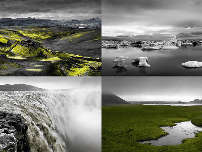
Iceland is now clearly visible for its rich nature, with the largest ice cap, the Vatnajökull glacier now being displayed in white.
Morocco also has greenery along the coast and in the north so that you can feel the vegetation.
At Mount Rainier National Park in Washington, USA, you can clearly see mountain ridges, white snow canopies, and the surrounding green vegetation. The boundaries of national parks can now be distinguished by the shade of green.
Croatian Mediterranean coast.
The Red Rock State Park in Arizona is now clearly marked as a desert area.
This change applies to all 220 countries and regions where Google Maps is supported.
Related Posts:


in Web Service, Posted by logc_nt