Facebook develops 'map by machine learning' and can be used for measures against epidemic
In the event of a disaster or pandemic, detailed mapping tools are needed to know exactly where to provide assistance and quickly. However, reliable and accurate maps are not easily accessible. The artificial intelligence (AI) technology has been used for the map developed jointly by Facebook and the Columbia University International Geoscience Information Network Center (
Mapping the world to help aid workers, with weakly, semi-supervised learning
https://ai.facebook.com/blog/mapping-the-world-to-help-aid-workers-with-weakly-semi-supervised-learning
How AI-powered maps help improve vaccination campaigns and rural electrification
https://tech.fb.com/ai-powered-maps-help-vaccination-campaigns/
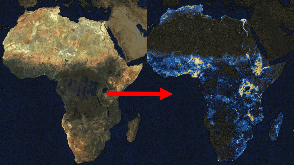
The Facebook project initially maps the 22 African countries based on multiple maps and satellite images, and finally the project is expected to map the population of almost the whole world.
In addition to being able to accurately evacuate at the time of disasters, it is possible for medical workers to quickly and properly carry out disasters by using a map that can accurately identify what kind of structure the region has, and what kind of population distribution. You can get in touch with people who are caught up in or who have an epidemic.
In fact, in Malawi, in southeastern Africa, a measles and rubella vaccination campaign was launched in collaboration with the Red Cross. Thanks to the map showing that 97% of the land area is unmanned, it has been successfully deployed in areas where volunteers are needed.
In Tanzania, where one in three people is said to be unable to use electricity, the AI map on Facebook confirmed that 'which area should I use for energy resources', which helped the electrical work plan.
Laura McGorman, director of public policy at Facebook, said, 'Because we started our career from dealing with malaria, we were able to directly see the important role that accurate data could play in humanitarian action.' He said he was confident that the mapping project could build partnerships with NGOs and relief organizations.
Although the census conducted by a country indicates the population living in a particular area, it does not indicate where in that area people live. Therefore, more detailed mapping is essential to efficiently allocate resources for efforts such as vaccination campaigns.
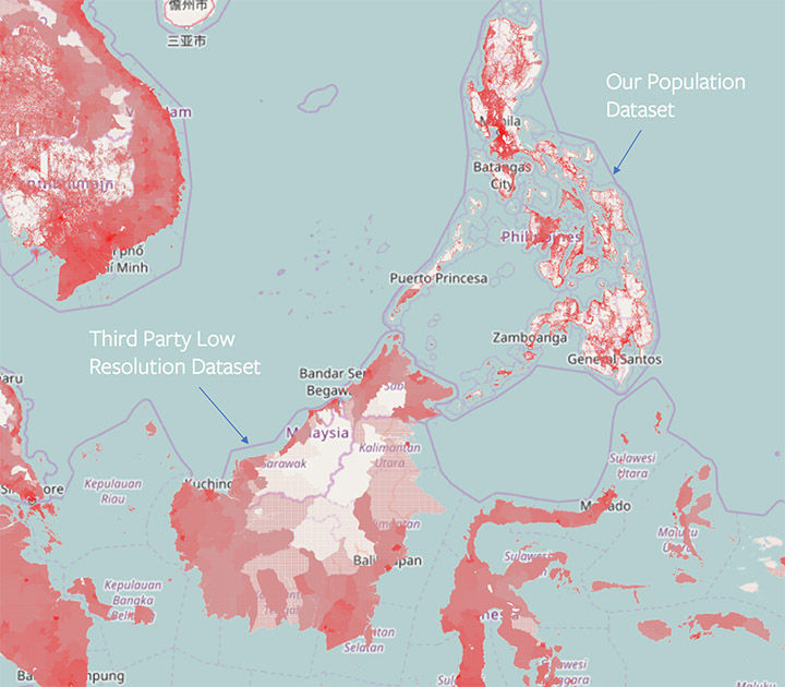
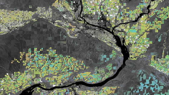
In this map using AI, when satellite imagery is read, it is predicted whether or not there is a building in it. Then, refer to census data etc. and calculate the number of people in a certain building and the number of people in a certain area from the population per area area. The image is a sample that Facebook is introducing, where locations including buildings from across Africa are ranked and top locations are shown with blue dots. If you click on the image, you can see how the population distribution is narrowed down by machine learning with the GIF animation.

Research data is provided free of charge from Facebook to local rescuers, and it is said that feedback is used for further research, but Facebook is using 'the fact that Facebook data is not used, of course, Census and satellite data do not contain personally identifiable information. ”
Related Posts:


in Science, Posted by log1e_dh