A map depicting what was meant to do with the world after World War II
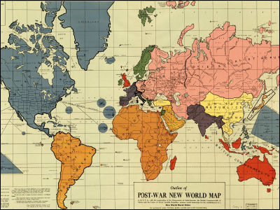
The Pacific WarThis "POST-WAR NEW WORLD MAP" was produced in October 1941 just before the start of the project. The content depicts what happens to the world after the Second World War, which Philadelphia map craftworker Maurice Gomberg was printing out in the store in 1942 with color printing. A person named Helen Summers acknowledged the significance of the map and bought several pieces, and one of the ones that was printed at the present time is said to be stored in the Congress Library in Washington, DC.
A plan is written in detail on the map, and the New World Order (New World Order), But the primary source of the plan has not been found.
After all, how was the plan of the postwar planned, details are from the following.
First of all, it is kore. The part painted with blue color is the United States and its protected country, the pink color is the Soviet Union.

North America is one color in America. Canada, Mexico, Central America, and the Caribbean countries have been incorporated into the United States, and it is stated that America will be without enemies in all of the land, sea and air. Actually, although the merger of the country did not occur, it is a result which is not much different from this map.

"South states (United states of south america)" is born in South America. Actually it did not go so well.

Up to Germany in Germany is the territory of the Soviet Union, France, Italy and Switzerland are depicted as the European Union of the Unarmed Union. Also, the UK seems to have lost its territory with let go of Ireland, but has a vast territory in Southeast Asia and Oceania. In fact Germany was split in the east and west and there was no unarmed coalition.

On the continent of Africa is drawn "Union of african republics", Arabian Peninsula "Arabian federated republics". I wish I had really succeeded in this street, but ... maybe.

Finally Asia. Japan has territories including Okinawa and the four northern islands, but Iwo Jima and the Ogasawara Islands are in the U.S. territory. In addition, China has also expanded to the Korean Peninsula and the Indochinese Peninsula, and from Afghanistan to Burma (Myanmar) all in India per Indian subcontinent. Indonesia with oil fields and gas fields is mostly British territory.

If the world were like this map, what on earth would our life be like now ...?
The summary of the plan under the map seems to be as follows.
The Pennsylvania Crier - NWO Map
Related Posts:


in Note, Posted by logc_nt